
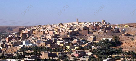
Ghardaïa is the capital city of Ghardaïa Province in Algeria. The commune of Ghardaïa had a population of 93,423 according to the 2008 census, an increase from 87,599 in 1998, with an annual growth rate of 0.7%.
Located in north-central Algeria in the Sahara Desert, it lies along the left bank of the Wadi Mzab. The M’zab Valley in the Ghardaïa Province was inscribed on the UNESCO World Heritage List in 1982 as a cultural property, evaluated under criteria II (for its influence on urban planning up to the present century), III (for its Ibadi cultural values), and V (as a settlement culture that has prevailed to the present century).
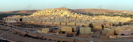
Ghardaïa is part of a pentapolis, a hilltop city among four others, built nearly a thousand years ago in the M’Zab Valley. It was founded by the Mozabites, an Ibadi sect of the Amazigh Muslims.

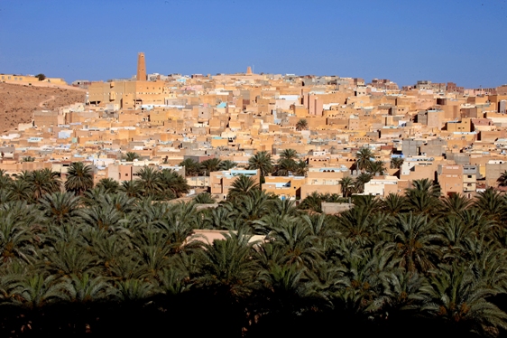
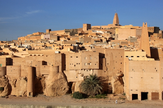
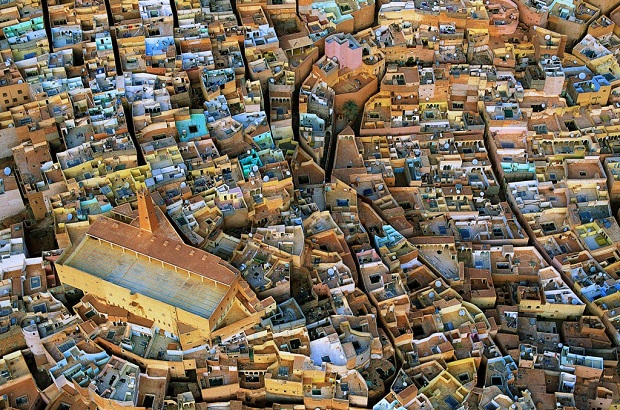
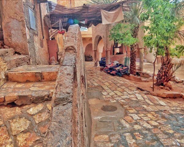
It is a major center for date production and the manufacture of rugs and cloths. Divided into three walled sectors, it is a fortified town. At its center is the historical Mʾzabite area, with a pyramid-style mosque and an arcaded square. Distinctive white, pink, and red houses, made of sand, clay, and gypsum, rise in terraces and arcades.
In her 1963 book ‘La Force des choses’, French existentialist philosopher Simone de Beauvoir described Ghardaïa as “a Cubist painting beautifully constructed.”
History
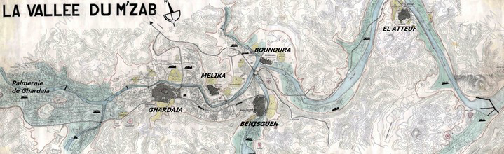
The M’Zab Valley, a limestone plateau, was inscribed on the UNESCO Heritage List for its unique conglomeration of five cities within an area of 75 km², located 600 km south of Algiers, the capital of Algeria.

The original architecture of the semi-desert valley dates back to the early 11th century. It is attributed to the Ibadis, whose cultural identity originated in the Maghreb; they had their capital at Tahert in an Ibadi Kingdom. Following a devastating fire in 909 (reportedly caused by the founder of the (Shi’ite) Fatimid Dynasty), they moved first to Sedrata and finally to the M’Zab Valley. They settled in five fortified villages on rocky outcrops, known locally as “Kosars.” Although they could have lived in one larger village, they chose to establish separate but similarly planned communities within a defensive environment. Ghardaïa’s foundation dates back to either 1048 or 1053.
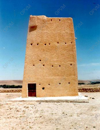
Each village was planned in a diverse topography, comprising a small island, a ridge, a hilltop, a peak, and a recess. The villages were fortified to be inaccessible to nomadic groups. The five villages – Ghardaïa, Melika, Beni Isguen, Bou Noura, and El Atteuf – were established with identical planning concepts. Each featured its own mosque with a minaret functioning as a watchtower, with houses built around the mosque in concentric circles and surrounded by high walls.

During the summer, inhabitants migrated to a “citadel” outside the fortified villages, in an informal setting with an artificial palm grove, a cemetery, and a mosque.
The ksar was created in 476/1085 by two tribes: the Aoulad Ammi-Aïssa and the Aoulad Ba-Slimane. Each tribe had its specific area and cemetery. Ghardaïa became the richest city in the M’Zab Valley, boasting dynamic commercial and craft activities. Socially, it was the only Ksar, along with Melika, that housed not only Ibadites Berbers but also Malekits Arabs and a Jewish community until Algerian Independence.
To build the Ksar, the founders of Ghardaïa chose a hill 200m south of the M’Zab Oued for defensive purposes. Farther west, they created a palm grove for subsistence farming. According to the public agency responsible for protecting the M’Zab Heritage, Ghardaïa underwent four phases of evolution until 1882, when it was annexed by the French army.

Top Historical Monuments to Visit in Ghardaia
The ksar
The Mzab planning has several features, despite the austerity imposed by the rigor due to the social ideal of rationality and functionality that is dictated by the harshness of the environment. The perspective image that the Mzab city (Ksar) offers is built with a mass standing on a rocky place, its houses clustered tightly and smoothly stepped terraces at the highest point, with the minaret drawn up into the sky announcing and protecting the city. By its order and compactness, the city reflects the coherence and cohesion of its social body.
Cities, as creations of men with long urban experience, were organized from the beginning, and urban structure indicates its priorities: mosques, walls, and streets of every city are all similar in their texture, elements, color, and particularly their understanding of the site. Ghardaïa holds on all sides a peak in the middle of the river. Melika is the tip of a ridge along the rocky plateau, Beni-Isguen occupies a convex, El-Atteuf is built on a ravine, and Bounoura was originally established on the top of a plateau on the edge of the river, and descended on the western side it no longer occupies the lower part.
Every town draws a line concentrically around the mosque and is surrounded by a wall of medieval type, a belt of semi-detached houses, making their own office wall.
DEFENSIVE BUILDINGS
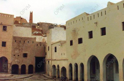
Each Ksar has a distinguished defensive system. In addition to the famous wall of Béni-Isguen, which was the first classed monument in Mzab in 1957, there are the front of the Ksar of Bounoura and the bulwark of Ghardaia. There are also garlanded ford towers throughout the valley, some dwellings in the environment and the palm groves, including the famous gateway cities. The whole constitutes with the minaret of the mosque an integrated defensive system.
The next step after choosing the location of the city is establishing the delimitation of its walls. These are interspersed with gateways and towers. The walls foreshadowed the outlines of the city. Once the houses’ walls were, in part, an element of defense infrastructure.
The cities are protected by ramparts and walls of houses, as well as defense watchtowers. The enclosure was monitored by bordj(tower)-shaped doors, forming the endpoint of the streets.
CEMETERIES
They are located outside the city. There are many, they are generally situated outside the M’zab old cities but organized by them and according to them. The cemetery is an integrated area with a real city of the dead. Its area is large and contains areas of funeral prayer, connected to buildings open to the air, serving as a place of worship for reading the holy Quran especially in winter, during which a rotation for the accomplishment of these rituals and service offerings are imposed on these areas every Friday.
Each area of the cemetery is named after a famous scholar, religious or social person, in general, is buried. The burial place is determined by family affiliation, according to a custom rigorously followed.
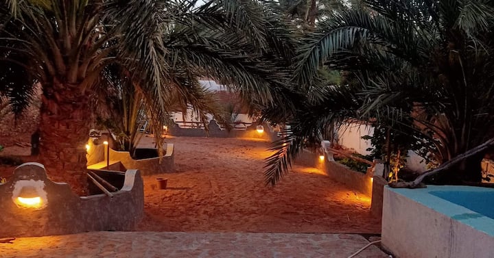
The Palm Groves
The palm groves are located near cities, they have many hydraulic structures, dams absorption, underground tunnels, wells, streams or artificial channels (seguia). These oases are becoming real towns of summer. More and more houses have been built to benefit from the relative freshness provided by the shade of palm trees and water in the hot season.
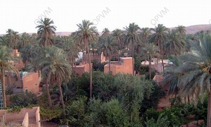
The palm of Mzab is more than a pleasure garden, it is the result of hard work, and formerly Mozabites possessed no fixed habitation in the oasis. We met there a few watchtowers or watchmen, armed, stood guard to prevent the population in case of danger and make it flow back to the ksours. Then it came to build simple zraib (mud huts) covered with branches and then made houses of mud and (therefore circa 1880), Mozabites, houses were built similar to the city.

Divided into garden plots, they are located near each Ksar, but on some ksar they spread longitudinally to fill long distances. The oases are an integrated architectural and urban planning. The gates are narrow, as being limited by the garden walls, built of clay, they are used to channel water from wadis flowing periodically in Mzab. At the base of the walls, the openings are drilled rigorously standardized and managed by a group of Amines responsible for the supervision of the irrigation of the palm.
The Hydraulic Structures:
The system of water sharing in Mzab is based on the principle of equitable and maximum utilization of rainwater and its fair distribution across the palm. In addition to the system, there are towers and spaces that allow continuous monitoring of floods in order to ensure proper distribution of water and avoid any damage that may be caused. These facilities are critical in creating the palm of Mzab. They continue to assume the same role in their preservation. This is why in large part, this irrigation system has been subject to periodic restorations.
The Traditional Distribution of Water Floods:
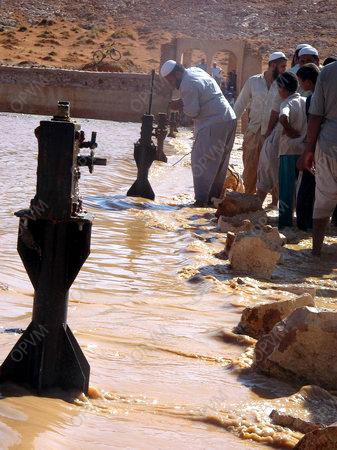
The M’Zab Valley is an arid and desert site where water is very rare. This has forced the founders of the Ksourian Mzab civilization to implement a hydraulic structure. They created a very effective system to capture floodwaters that supplies wells and groundwater by storing water in reserves for the taming of the M’zab Wadi flood.
It features a sound management system of high precision and extreme rationality. This system consists of several dams, wells, water channels in the streets and underground channels that direct water to the palm groves.
The distribution paths in channels extend up to a distance of three to four kilometers from the source. This ancestral masterpiece is still functional. This complex hydraulic system from the 14th century consisting of dikes, canals, seguias, tissanbads, rasfates, wells, etc. has been managed since its inception by a committee of wise experts, called “Oumana”.
The Mosque
Mosques of the ksars, mosques of the oases and surfaces of funeral prayer. The interest of these buildings lies in the simplicity of their form contrary to the other mosques in the Muslim world which are distinguished from the urban setting of their establishment and by their imposing form and their excessive decoration.

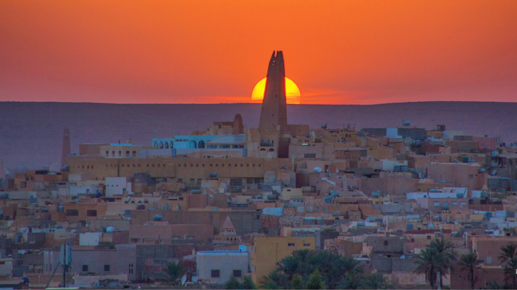
The mosques of Mzab on the other hand merge in the ksars without being distinguished from the whole of the homes around them. Regarded as the directing and structuring element of the city, it sits in the center of the ksar, imposing the city by its volume and dominant position. This position as well as the obviousness of its minaret (of an imposing, pyramidal lengthened form), shows the importance of the mosque; and its minaret occupies the highest point. In the mosques of Mzab, simplicity was scrupulously adopted, at all levels; inside and outside.

Homes
In Mzab, the dwellings in the ksars revolve all around the mosque. Their forms are different and irregular. The surface of the majority of them does not exceed 100m2, their external height and the distribution of their dependencies are adopted in accordance with the customs and habits of the society, the nature of the area and religious, social, medical standards… etc. The habitat is composed of two floors and a terrace.
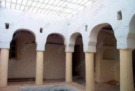
The space of a dwelling is structured the same process of setting in a network of simple cells. The house is connected to public space (dead end or street), by an entry out of baffle. The patio is the vital place of the house, from which the distribution of spaces and the functions is carried out. The central opening in the middle of the ceiling allows air circulation and ensures lighting. On this space the room “tisefri”, or the women’s living room, with a corner arranged to be a kitchen and another to be a bathroom. A staircase gives access to the next stage which, is structured in a similar way to the ground floor and is provided with two gantries.
The market yard
They are built by the places of the market (souk) established in the ksars. Each one of these places is characterized by particular characteristics. As a whole, they still undertake the role of structuring the economic activity since their creation. In their turn, they were the target of multiple operations of restoration.
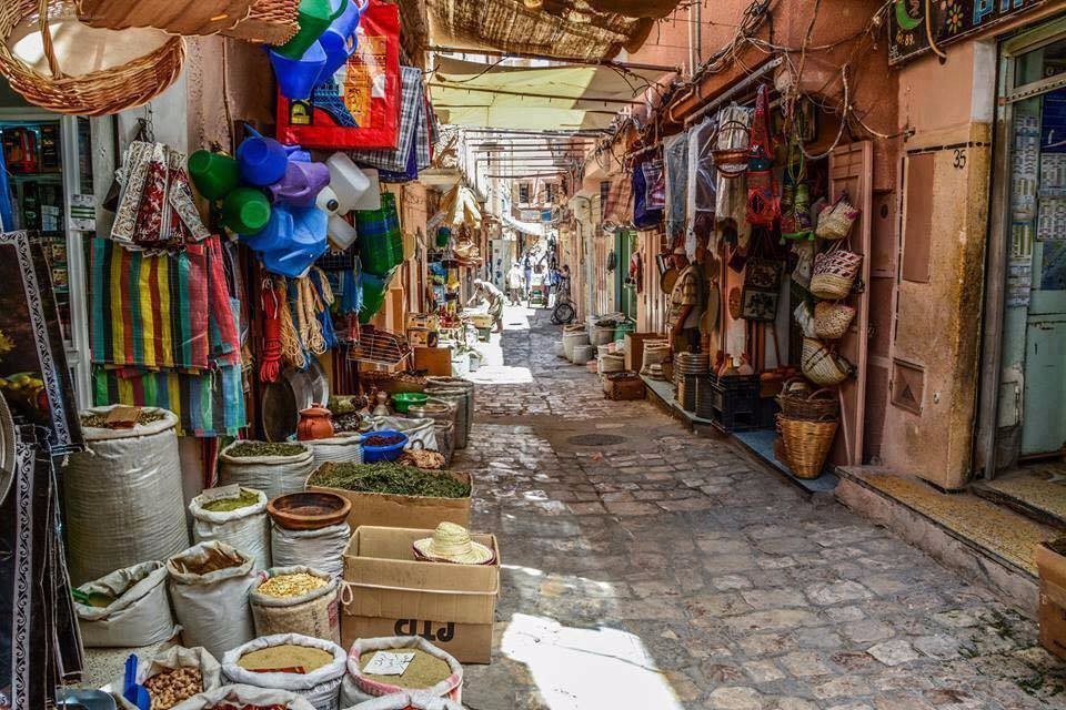
The souk is an adjoining place to the main entrance. It is an intermediate space between the inside and the outside of the city to keep its vocation of space of junction to the end of the city, its site develops according to the evolution of its ramparts.
The souk is the activity center of the city and the public center; place of attraction, transaction, noise, and meetings, it is deliberately situated at the periphery of the city. Its position concerns on one hand, its mission in terms of goods supply that requires an easy access, on the other hand, of a social representation of the space which separates life privacy from public one, like the holy from the unholy.


Lanes
Inside the cities, circulation is carried out through generally narrow lanes, they are partly covered sometimes, protecting from the hard frosts and the solar rays, and allowing the air circulation which softens the temperature according to the nature of the ground; they are often tortuous and very inclined.

In the contours of the hill settlement, the streets of Ksar are sinuous at the discretion of relief.
THE CONSERVED AREA
M’zab Valley is a region of northern Algerian Sahara, looking like a vast rocky plateau cut in deep and intricate valleys hence the name of “Chebka” meaning net. The cretaceous plateau is formed by hard limestones of the Turonian. It is furrowed in every direction by fluvial erosion of the early Quaternary and crisscrossed by a complex network of wadis which form the four major valleys. The M’zab river crosses it Northwest. Southeast. This configuration has earned the region the Arabic name “Chebka” which means lace, net.
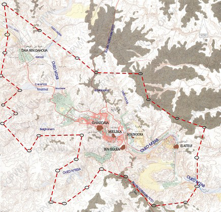
Ghardaïa, its main city, is located at a distance of 600 km southern the capital Algiers. It runs along the M’zab river over an area of 25 km.
The wilaya of Ghardaia has experienced different historical periods, from prehistory to the present day, through the Islamic period. The remains and monuments that bear witness are, for the majority, in fairly good condition. With its rich historical experience and cultural values that have distinguished the region (particularly M’zab Valley) has been classified as “national heritage” by the Algerian State (1971) and part of the “universal heritage” “(UNESCO -1982), and conserved area in 2005.
M’zab Valley contains towns and oases, which are distinguished by their urban appearance remarkable and unique. As such, it has unsuspected potential for tourism and economy.
Human activity in the M’zab region experienced several historical stages, starting with prehistoric times through the Islamic Period that left remains existing today.
In three and a half centuries, the eleventh century to the fourteenth century, a process of urbanization of the valley led to the creation of five cities: El-Atteuf, Bounoura, Ghardaia, Ben-Isguen and Mélika. Each city has a palm grove, an irrigation system and cemeteries. Living isolated from the outside world with the sociological, religious, economic, cultural and linguistic specificities, M’Zab population was able to overcome all interference and sociocultural invasions for ten centuries.
KSAR OF ELATTEUF
El Atteuf, the eldest of the Ksour, was founded in 1012 downstream of the M’zab Valley by Sheikh Khalifa bin Abghour. The Ksar is the starting point and the start of a process of urbanization in the M’zab valley. Among the peculiarities of the Ksar, the existence of two mosques in its precincts. Each of these has its own pyramidal mosque minaret.
El Atteuf has celebrated its millennium in December 1996 under the slogan: “Cheerfulness, Hope and Love of Algeria”. It was a real snap, allowing a true urban and architectural renewal. So the Ksar has been given a special attention to safeguard and promote local architectural and urban heritage via the rehabilitation of old construction techniques.
SQUARE OF EL ATTEUF MARKET
It is located on the north-eastern side of the Ksar. This is a place of friendly exchanges and business transactions via the auction sale. This market has an estimated area of 560 m2, the market place is surrounded by galleries and arcades of different sizes and dimensions within which there are fractions of houses.
On the occasion of the millennium the place has been subject to a large-scale restoration that has affected all of its components by making the necessary architecture corrections.
It is in this place where the festivities were held to commemorate the millennium of the city of El Atteuf and M’Zab Valley in 1996.
MAUSOLEUM OF SHEIKH AMMI BRAHIM
Situated below on the south side of the Ksar, founded in the 15th century, this monument is a mosque and burial fraction adjacent to the tomb of Sheikh Ammi Brahim.

This mosque has a room half of which is underground. It is surmounted by a small room in half level as compared to the ground and the ceiling of the whole. The great hall at ground level outside is opened by arches on one side, and a wide screen wall above the tomb of Sheikh Ammi Brahim. A whole wall is pierced with niches and half-moon shaped openings. Pillars with irregular implementation bear bows and battens that support palm-trunk girder.
Terrace covers all accessible by a staircase outside and surrounded by a parapet wall that the perimeter of the mosque. An area prolongs the prayer hall.
The Ksar of Bounoura “AT BOUNOUR”
It was founded in 1048 on the top of the hill at the foot of that cross the M’zab Oued with one of its tributary “Oued Azouil”.
Reading urban organization reflects the existence of two Ksours on this site. The first part now in ruins except that the mosque and the fortifications were restored, occupied the highest part where you can still make out the narrow alleys and size of homes that are smaller than those of the extension made during the thirteenth century and currently inhabited.
The characteristic of this second Ksar is the use of the boundary of the rocky plate with the Wadi as a base for rampart houses forming a true defensive front to the west, reaching a height of 20 meters. On the opposite side, at half-height of the small hill, the fortifications of the first core are the eastern boundary of the current Ksar.
As for each of the M’zab pentapole Ksar, Bounoura is surrounded by vast cemeteries that span large areas and almost surround the city. These real cities of the dead occupy a very important place in the collective memory and by respect they are the only areas where construction does not exist. This fact prevents suffocation of Ksar guaranteeing it an area free of construction.
THE FRONT OF BOUNOURA
Located in the western part of the Ksar Bounoura. It is in the form of a belt of ramparts houses perched on a rock overlooking the M’zab Wadi on the western part of the Bounoura Ksar. It is presented as a kind of natural trapping.

The dwellings are houses ramparts perched on a huge rock carved by the river, the exterior walls of the houses are pierced with small openings which are just the windows of homes, they are reduced to the status of watching for, as in other ksar houses, they take their lights and ventilation central patio.
THE MOSQUE OF THE OLD KSAR
Founded in the eleventh century. Bounoura’s old mosque located in the center of the original core of the Ksar Bounoura.
The dimensions of the mosque and its minaret are smaller than other cities of the Pentapolis, since proportionately less important to the needs of first settlement, it is now in ruins, was inhabited mostly by families who have emigrated to the ksar of Mélika, following a civil war, many centuries ago.

Due to the effect of abandonment and natural aging, the mosque has fallen into disrepair. However, thanks to the regain of consciousness of the ksar citizens and collaboration of specialized architects a great Touiza campaign has been organized to restore it.
The use of traditional techniques and building materials recovered on site, on the basis of a comprehensive study of its structure and organization have allowed the restoration of this monument by restoring its original status.

Irregularly shaped, the mosque consists of a prayer hall, whose pillars and arches, very simple shapes, bear the cover on the terrace, and a large prayer area surrounding it.
THE KSAR OF GHARDAÏA
It was founded in 1057, Ghardaïa “Taghardaït” also called the pearl of the oasis and the capital of the M’zab Valley, is located upstream of the M’zab Valley, and is organized around a hill.

At the top, and in the middle, is the great mosque, which is considered the focal point around which gather all other elements of religious and wordly life.
Ghardaïa is the largest city where are found the largest concentration of facilities and social cultural and economic infrastructure. It has an almost perfect radio concentric geometry marked by rising and climbing streets all converging to the end of the journey to the Big Mosque.
In the first nucleus of the Ksar, the market called “Rahba” once specialized in the sale of pottery, now devoid of its function. The current market place against a very dynamic one is part of the outer extension of the city.
The Ksar is surrounded by several cemeteries, real dead cities that remain to date the only areas not affected by the operations of extension. These cemeteries contain funerary mosques, places of worship that are not covered (m’çolla) and tombs of illustrious scholars and men of worship.
The Ksar recently received special attention consisting of backup plans in the permanent objective of the development of historical monuments in addition to its restoration and rehabilitation. The initiative has been a continuous task to cover all community buildings and homes that also require a support point of view protection and restoration for better preservation of architectural character of the site and improving the living environment of its inhabitants.
THE BIG MOSQUE
At the foundation of the Ksar of Ghardaia in 1048, it was the first building to be built on the highest point and most dominating of the hill.
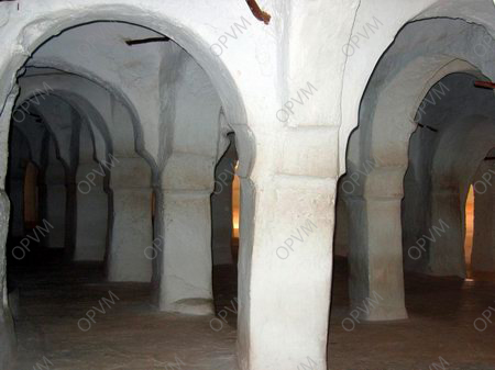
In addition to two prayer rooms, several other infrastructures built around the mosque including “Mahdrates” located to the north and are reserved places for learning the Holy Quran, as well as a management and monitoring defense system of the city.
The mosque also has two minarets, the first, oldest, and much smaller in size, not exceeding six feet in height, and it currently remains at the top, the bottom being cleared to allow passage , the various works of extension. The second minaret, founded in the 16th century during the era of Sheikh Said Ammi, it stands as a pyramid, in turn at 23 meters from a base of about six square feet.
The different corners of the great mosque remain lively even after hours of prayer.
However, and unlike other mosques in the world, the mosque has a very specific feature related to the M’zab usually it is devoid of any decorative or superfluous elements.

THE SQUARE OF GHARDAÏA MARKET
The marketplace of Ghardaia called “Azghar Ougharme” meaning outside the city, is located on the southwestern outskirts of the Ksar. Frequented by caravan traders from distant lands, this place remains to this day the most dynamic market of the entire region. The market square was founded around the year 1884.

Rectangular in shape with a surface to about 3400 m2 this place is surrounded by a shopping arcades in various shapes and dimensions, in which we find shops and small businesses.
The streets leading to the market place have an economic role in their nearest part of the souk. In the past, each type of commercial activity was in a limited area and there were vegetables on the street, the street grocers, street tailors, embroiderers that, etc. while the place was open for the sale of products from outside such as salt, spices, wheat, wool, livestock, etc.
The market place had in the past an area of prayer “M’çalla” elevated and facing the west side. The middle of the northern half of the square is the “Houita” which is a line of boulders embedded in the ground and arranged in a semicircle of about 5m radius. These stones were once the seats of each member of the “Djemaa” (assembly of notables of the Ksar) who settled there to discuss the affairs of the city.
In October 1997 the market place – for the first time in its existence, knew a large-scale rehabilitation and restoration thus restoring its true historic face (meeting place for exchange and conviviality).
This has affected all components of the market place starting with the architectural treatment of facades corrections, restoration of damaged elements, consolidation of beams and ripe, plastering, tiling. The main purpose of this operation being promotion and rehabilitation of the local architectural heritage.
SYSTEM OF FLOODWATER DISTRIBUTION
Distribution system of rainwater has been implemented more than eight centuries ago, the two scholars: Sheikh Ba Mhamed Abu Sahaba in 1273 and Sheikh Hammou Oulhadj in 1707 settled the rainwater distribution system, the storm water is found at the bottom of the palm upstream about 4 km west of Ksar.
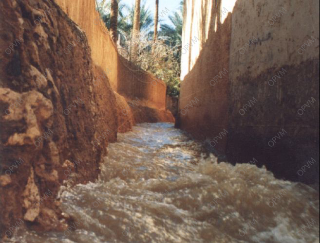
Rainwater is channeled from the watershed of Oued M’Zab extending upstream for several hundred kilometers, in a natural way to a place called “Amlaga” which is the focal point and meeting place of two of the most important Wadis. Labiad Wadi and Laader Wadi.
At this level the Oumana “Men who have responsibility for the management of the watershed” has built the first hydraulic structure whose function is to slow the speed of flood waters and then distribute it to the irrigation of gardens and Bouchene dam to supply the water, the surplus is diverted to the bed of the M’zab Valley Wadi up Al-Etteuf.
The watershed to the gardens is formed by a system called “Tissenbad N’Bouchéne” which consists of three major underground channels equipped with ventilation Fougaras that allow access for cleaning. Each of these canals opens into an alley-channel at the palm groves allowing the flood water to reach the gardens through slots carefully sized for the number of palm trees and on the surface to be irrigated. It should be noted that the palm which is an artificial oasis, owes its existence thanks to that efficient and ingenious system.
THE KSAR OF MELIKA (ATMLICHET)
Melika, founded in the early eleventh century, is located halfway between Beni Isguen and Ghardaïa, on the east side of the bed of the M’Zab river. It remains a symbol of brotherhood, coexistence and good neighborliness between peoples of different origins.
Unlike other cities, Melika has a market square adjoining the mosque, which is at the center of the Ksar, at the intersection of two main north-south and east-west streets. It is also the only Ksar of the valley that, due to the physical location of its land, has not been extended.
The people of Melika were known for a time to hold the exclusive business of the manufacture of green pottery.
The Ksar has been granted a specific study plan consisting of permanent backup in addition to various restoration operations that affect certain monuments and works regularly with the community goal of preserving the urban character of the Ksar and improving the living environment of residents.
TOMB AND MAUSOLEUM OF SHEIKH SIDI AÏSSA
The tombs of Sheikh Abu Mahdi ben Aissa Smail and his disciples are in the north of the Ksar of Melika, within a large cemetery regarded as a true city of the dead.

Sheikh Sidi Aissa came from the highlands of Ouled Nail. In 1500, he had many disciples in the valley and other parts of M’Zab, as well as Djerba in Tunisia and Libyan Jabal Naffoussa. He left many writings in various fields such as fiqh, literature and other sciences.
Melika, his adopted city, remained loyal to him, dedicating the privilege of raising his tombstone and those of his disciples, making them into small works of Timchemt (local plaster). These works, treated as surreal sculptures with their pinnacles of varying heights, offer a unique and unparalleled visual image.
In front of these tombs is a spread out area for prayer where the people of Melika gather for funerals and “ziyara” or visits. The “ziyara” is held annually in the spring by the “Azzaba” (council of elders) and consists essentially of disclosing local history to perpetuate knowledge of the collective memory.
The Sidi Aissa mosque, on the edge of the cemetery and near the walls of the Ksar, was an integral part of the overall architectural landscape of these places, but unfortunately it was destroyed in the 1960s.
THE KSAR OF BEN-ISGUEN (AT-ISDJEN)
It was founded in 1350. Since its foundation, Beni Isguen (At Izdjen) has preserved its organizational model completely, including all of its walls lined on the inside by an alley along its perimeter with watchtowers. It is a city rich with library rooms in houses where one can see many manuscripts and books on various aspects of society and its Ibadite legislation (agriculture, law, fiqh, hydrology, architecture, etc.).
The Ksar of Beni-Isguen is located on the side of a peak halfway between the Ksar of Melika and the Ksar of Bounoura, at the confluence of the M’zab Valley Wadi and the Ntissa Wadi, the latter being its natural limit. The two main doors located in the North and South (Bab Chergui and Bab Gherbi) and three gates lead to the different cemeteries. Access to the top of Bordj Boulila, located on the highest point, allows a panoramic view of the palm grove and a reading of its privileged urban organization. All streets lead to the market place, which is triangular in shape. Every day, in the late afternoon, except Friday, the ancestral auction sale is held there.
The water supply was provided by wells distributed among the various districts to allow for the supply of inhabitants. To cover the cost of maintaining the wells, palm trees were planted next to each one, and dates are sold at the market.
The Ksar of Beni-Isguen has benefited from backup, restoration and rehabilitation. These mainly affected the entire defensive works, in conjunction with operations to restore old houses to safeguard the architectural and urban planning of the city and to improve the quality of life for its inhabitants.
THE BOULILA TOWER AND THE BENISGUEN RAMPART
The city of Beni-Isguen is surrounded by a great wall 1525 meters in length and 3 meters in height, with a thickness up to 1 meter at the base and 20 cm at the top.
Built in the fourteenth century, the bulwark of Beni-Isguen reached its present form only after the last extension in 1880.

The wall has watchtowers, whose larger Bordj Boulila two main gates, Bab El Chergui and Bab El Gherbi and three other gates.
The wall, and watchtowers have been targeted recently by a series of restoring operations. The operation is still in progress in parallel with a consistent and continuous monitoring in space and time.
THE MARKET PLACE
Around the year 1860, according to the gradual and continuous extension of the city of Beni-Isguen, the market place was moved to the place called “Lalla Achou,” which is the current market place for the auction sale. This place was named after a holy woman known as “Lalla Achou,” whose place was formerly used as agricultural land and later converted for use as a market for the Ksar.

This market place is located far from downtown, on the outskirts of the Ksar. It is triangular in shape, with side lengths of 30 and 59.56 meters, and has an area of 806 sq meters. The open shops and deposits are surrounded by masonry benches, well fitted to its most acute angle.
The market of Béni-Isguen has not experienced a break in its traditional business, only flexible renovations.

The biggest feature of this place is definitely the auction sale held just after the daily afternoon prayer of “Aasr,” except on Fridays. Business transactions are conducted under the watchful eye of members of the assembly of “Azzaba.”
OTHER CLASSES SITES
THE KSAR OF BERRIANE
It was founded in 1690 and is located 552 km south of Algiers. It is situated on an isolated rocky hill with a total estimated area of 27 hectares.
The classified perimeter covers the Ksar and surrounding oasis. The Ksar of Berriane embodies the overall concepts that led to the construction of the ksour of M’Zab Valley. Its style is similar to that found in the cities of Mzab. It still resists the onslaught of novelty due to its deep anchoring in the daily life of the people and the quality of its link with the environment.
The regions of Sidi Mbarek Ballouh are characterized by the presence of prehistoric rock carving stations. The palm groves are irrigated by the Oued Ballouh dam.
The craft of Berriane is well known. Historian Sheikh Mohamed Ali Debbouze was one of the great scholars of the city of Berriane. It was classified as national heritage in 1998.
THE KSAR OF GUERRARA
It was founded in 1630 and has particular importance, since it represents the first transplantation, one hundred kilometers away from the M’zab valley.
It is also worth noting that the oasis of Guerrara has a large number of facilities that require preservation, as they reflect the history of this region.

It is also worth noting that the region contains many remnants of ksour before the founding of Guerrara, such as the Ksar of Lahmer and the Ksar of Lambarthakh. It is a trove of rich natural sites that offer a variety of impressive panoramas, including many Sahara “Meida”.
It was classified as national heritage in 1998.
THE KSAR OF METLILI
The Ksar of Metlili, located 40 km south of Ghardaia, is built on a rocky knoll on the banks of the river. It covers an area of approximately 8.5 hectares, occupying a quadrangular space. It is bordered by rocky hills to the north and east, by the highway to the west, and by the river of Metlili to the south. In its lower part, the structure of the roads is fairly regular, with two main directions, while in the upper part there are steep rocks and cliffs which influence the movements of the streets. Generally the roads are laid out; the main streets are wider and more lively, especially the most important one with many squares.
Among the most important landmarks in the Ksar are the mosque with its minaret, the place of “Zaouïa Sidi Hadj Bouhafs,” and the series of squares with their shops.
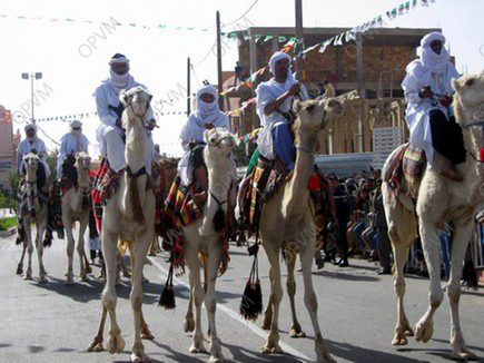
Each spring the locals celebrate the “MEHRI” festival. During the festivities, visitors flock from across the country and all over the world to attend. Some race their MEHRI (dromedary camels).
The ksar of Metlili was classified as national heritage in 1982.

THE KSAR OF EL MANEA
Located 270 km south of Ghardaia, the old Ksar is situated in the eastern part of the city of El-Menéa, within the “Lemmedhi” district, approximately one kilometer from downtown.
The old Ksar is built on a pyramid-shaped hill rising about 75 meters from the riverbed of the Oued M’guiden. The Ksar dominates the palm grove and the accesses to surrounding areas of El Menéa.
The old Ksar of El-Menéa was founded in the early tenth century by the Zenetes from the regions of Timimoun and Gourara. Many peoples have inhabited the old Ksar over time. Its first inhabitants were the Zenetes. The Ksar lived under the authority of a Zenete queen, “M’Barka Bent El Khass.”

The Zenete era was characterized by great achievements in palm tree planting, which led to great prosperity in the region. The Ibadite merchants of the “At Khefianes” tribe also inhabited the Ksar. But starting from the sixteenth century until its capture by the French army, the Ksar was occupied by the “Chaamba Lemmadhi.”
The Ksar is built on an isolated, dominating hill and appears as an island among overwhelming sand dunes. Its design is essentially defensive and expresses the genius of its builders.
The old Ksar is the only historical witness in the El-Menéa region and thus represents the only historical and architectural heritage. It has confirmed historical, archaeological and architectural value.
It was classified as national heritage in 1995.
BUILDING MATERIALS
The pressing need for people to adapt to the site and harsh climate, which has considerable temperature variations, forced the population of the Mzab Chebka to optimize the use of available local materials. These provided the requirements of solidity and isolation without neglecting aesthetics, which distinguishes any architectural work.
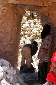
1) Stone:
White limestone extracted from the surface rock layer. It is presented in various sizes, adapted for transport to the workplace. Its final size is the work of the builder who makes appropriate adjustments based on the nature of the house. Once raised, the wall is covered with a layer of lime mortar to give it a uniform appearance.
2) Lime (Aljir):
Available abundantly in the area. It is extracted from the surface layer of hills, laid out in kilns about two meters high. It is burned in the same manner as the plaster Timchemt, but consumes 5-6 times the quantity needed for plaster, making it more expensive.
3) Plaster (Timchemt):
Local plaster with an ashy-white color extracted from surface layers or fields to a maximum depth of one meter. This plaster is burned in a kiln with a bottom opening, fueled by wood and scrap. The gypsum is piled to a depth of about one and a half meters and burned for twenty-four hours. When the wood is consumed, the stone softens. The plaster is then separated from waste and readied for use.
4) The adobe (Tleght):
Bricks manufactured from clay soil. After soaking in water, the clay is mixed then poured into molds. The molded bricks are left to dry in sunlight. Sometimes straw is mixed into the clay to make stronger bricks.

THE INTANGIBLE HERITAGE
The 2003 UNESCO Convention for the Safeguarding of Intangible Cultural Heritage defines “intangible cultural heritage” as the practices, representations, expressions, knowledge and skills that communities, groups and individuals recognize as part of their cultural heritage. This heritage, sometimes called “living cultural heritage,” covers:
Oral traditions and expressions including language, performed arts, social practices, rituals, festivals, knowledge and practices related to nature and the universe, and know-how linked to traditional crafts.
Transmitted from generation to generation, intangible cultural heritage is continuously recreated by communities and groups based on their environment, relationship with nature, and history. It provides people and communities with a sense of identity and continuity. Safeguarding this heritage promotes and nurtures the development of cultural diversity and creativity.
Crafts:

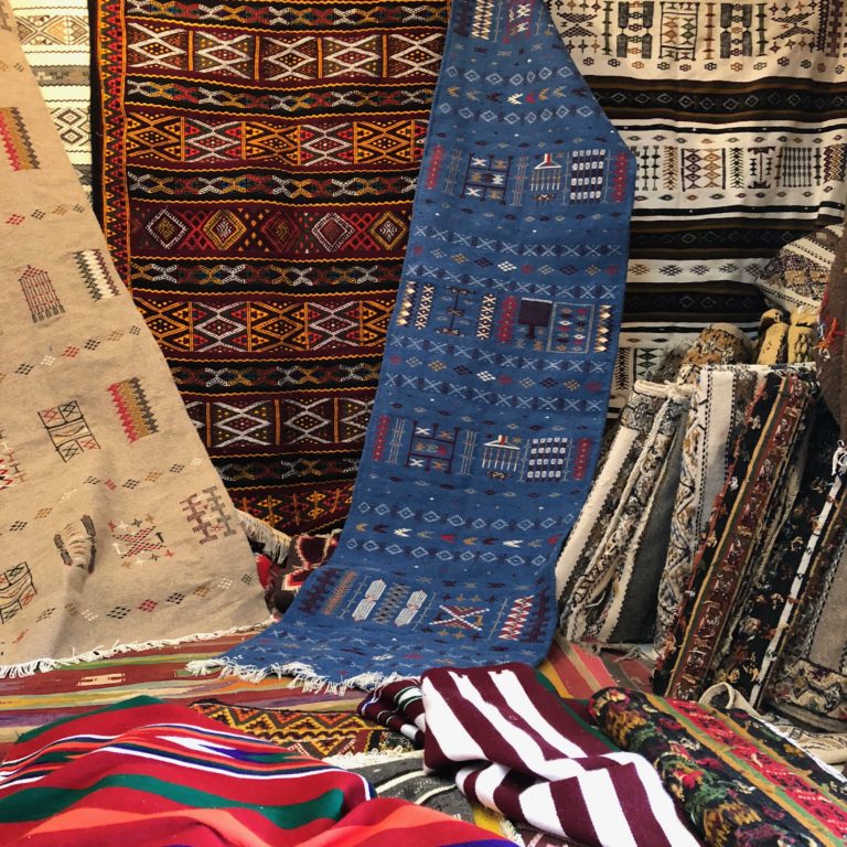
Ghardaia has long been known for its variety of crafts, including carpet weaving (wool carpets, berber carpets, cushions, etc.), a traditional weaving renowned for its uniqueness, authenticity and artistry. Wool work provides several types of garments like family cloaks, robes, and gowns. Other crafts include brassware, pottery, and leatherwork.

FESTIVITIES AND MOUSSSIME OF THE WILAYA OF GHARDAÏA
The “Yennar” Festivity:
January, Amazigh New Year – celebrated annually by preparing a sweet dish called “Arfis”.
“Fourar” February:
At the edge of spring, locals make visits to shrines and holy sites in the region for Dikr circles and donations.
Carpet Feast:
Each March, Ghardaia hosts a parade of floats decorated with carpets from different regions, along with a crafts fair, games and folk songs.
Month of Heritage:
Throughout the towns, scientific and cultural heritage events are held between April 18 (World Heritage Day) and May 18 (International Museum Day).
Birth of the Prophet Mohamed:
The popular regional festival, with religious hymns and family visits. In Ben Izgen, children light oil torches, and oil is traditionally gifted to the mosque.
“Aamar” Festivity:
In early summer, Ksar residents move to summer homes in palm groves. Children wear traditional clothes, and palm grove cleaning campaigns are conducted by the “Oumana” water management assembly.
Ksar of El Ménea Celebration:
The 10th century Ksar’s founding is celebrated with cultural festivals.
Collective or Group Weddings:
Ghardaia is known for organizing collective weddings to support poor couples.
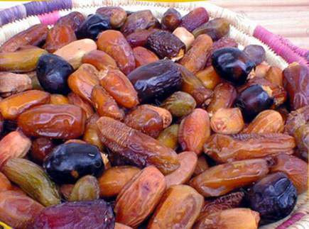
Palm Date Harvest:
150+ date varieties are celebrated at grove festivals and fairs across the region.
“Achoura” Feast:
Religious festival in the month of Muharram with traditional dish “Ibaoun,” songs and family visits.
“Allay” Feast:
In early winter, palm grove residents return to the Ksar. Girls wear traditional clothes and a wheat dish is prepared.
El Hadj Season:
Marked by songs upon pilgrims’ return from Mecca.
“Mehri” Camel Feast:
Annual camel racing festival in Metlili City.
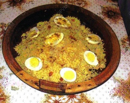
GASTRONOMY:
Rich, varied traditional dishes and spices.


Al Habib farm in Ghardaia province


