The Sahara Desert, the world’s largest, spans 5,000 kilometers from the Atlantic Ocean to the Red Sea, covering over 8 million square kilometers – an area as large as Australia and New Zealand combined. It traverses ten African countries: Morocco, Algeria, Tunisia, Libya, Egypt, Sudan, Chad, Niger, Mali, and Mauritania. The desert’s boundaries are somewhat indistinct, extending even beyond the Red Sea, leading geographers to speak of a larger Sahara-Arabian desert. Contrary to common belief, sandy deserts make up only 20% of the Sahara. The region also includes mountains, hamadas, regs, and vast sand sheets like the Majabat al Kubra. The Sahara experiences extreme temperatures, reaching up to 55 °C, with nighttime drops to 15 °C and even to 0 °C in winter.

A Historically Rich Place
The Sahara wasn’t always inhospitable. Thousands of years ago, it was a lush area with rivers and mountains, as evidenced by cave paintings showing abundant fauna and flora. Now, it’s dominated by sand, rocks, and strong winds, with sandstorms common in this plateau situated 200-500 meters above sea level. Despite its harshness, the Sahara is home to 2.5 million people.
Saharan Population
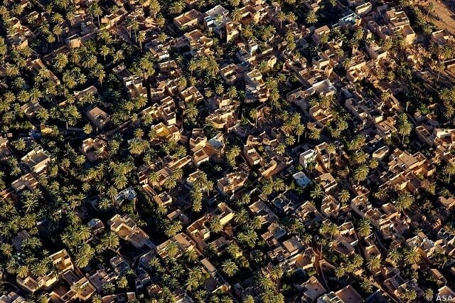
The Sahara’s population has deep historical roots, with evidence of prehistoric human activity (tools, pottery, cave paintings). Around 6500 BC, the Sahara was still wet, but it became arid around 3900 BC, driving populations towards the Nile Valley and contributing to the development of complex societies. Today, many inhabitants are nomadic, with an estimated 1.5 to 2 million people, a number that is decreasing as nomads increasingly settle in expanding cities. The Sahara hosts three main groups: the Moors, the Tedas, and the Tuaregs, who cultivate small areas in oases, primarily growing date palms. Wadi Rhir in Algeria is renowned for its date production, with other crops grown under palm groves. The Sahara is also economically significant for its rich mineral resources, including gas, oil, and uranium, mainly exploited by Algeria and Libya.
Fauna of the Sahara
In the Sahara’s challenging climate, only certain animals, particularly insects, can survive: fennecs, jerboas, vipers, scorpions, and notably camels, which are essential for the Tuaregs’ mobility. Nomads travel between oases to water their herds, typically comprising sheep, goats, and camels.
Tourism: A 20th Century Development
Tourism in the Sahara is a relatively recent phenomenon. The desert’s northern limits were first flown over in 1919, but it wasn’t until 1922 that the Citroën mission crossed the Sahara by car. Today, various tourism activities are offered, from trekking to off-road adventures. However, the intensifying climate poses increasing challenges, gradually making the region less hospitable for human habitation.

The splendor of Algerian sunsets offers a breathtaking spectacle, especially during times of uncertainty. These sunsets symbolize both an ending and a peak, ushering in a realm of new possibilities. The sky, adorned with a kaleidoscope of hues, reveals stunning shades of pink, yellow, orange, and sometimes even red. Each sunset is a unique display, culminating in the renowned “Golden Hour.” This magical moment, marking the day’s end, allows the sun to showcase its full, resplendent brilliance, casting a warm, golden glow that captivates and inspires.
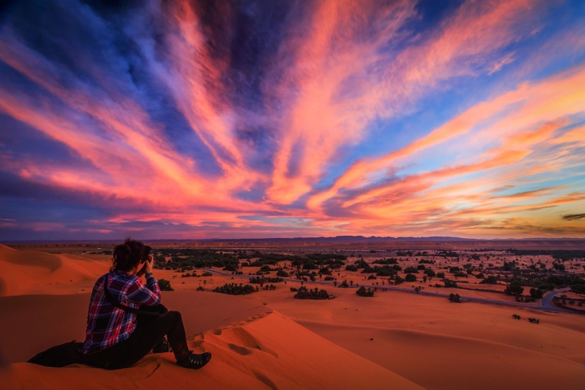
The sunset in Algeria holds a special place, not merely because of national pride, but due to the profound impact it has on the soul. In this magical moment, as the sun dips below the horizon, it offers a brief respite from life’s hardships — the pain, tragedies, disappointments, illness, loss, and all the burdens weighing heavily on weary hearts. This isn’t just an ordinary day’s end; it symbolizes the hope for a brighter, sunnier tomorrow.
Moreover, the sunset’s incredible beauty is like a live painting, a masterpiece of infinite art graciously bestowed by nature. It serves as a reminder that life isn’t just black and white or purely gray; it’s a canvas splashed with a myriad of colors. These sunsets illustrate that sometimes, it’s the small things in life that can add brightness and color to our existence.
So, lift your gaze to the sky and behold this divine spectacle with the wonder of a child, whether alone or in the company of someone dear. This moment, in its simplicity and grandeur, is a testament to the beauty and resilience of life itself.
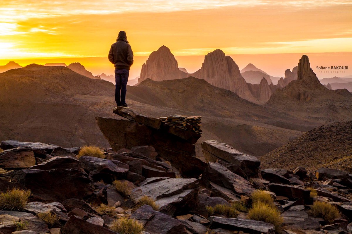

The Hoggar Mountains in Algeria are a mesmerizing highland region in the central Sahara, situated along the Tropic of Cancer. Spanning an impressive area of approximately 550,000 square kilometers, this mountainous terrain is about 1,500 kilometers south of Algiers, the capital. The region is predominantly a rocky desert, with an average elevation exceeding 900 meters (3,000 feet) above sea level, painting a landscape of stark beauty and grandeur.
Mount Tahat, the highest peak in the Hoggar Mountains, stands tall at 2,908 meters (9,541 feet). These mountains are primarily made of metamorphic rock that is about 2 billion years old, offering a glimpse into the earth’s ancient past. However, the region isn’t just about antiquity; it also showcases areas where more recent volcanic activity has deposited newer rock formations.
One of the most striking features of the Hoggar Mountains is the dramatic peaks formed through erosion. Peaks like Ilamen are the remnants of extinct volcano domes. Over time, erosion has worn away the softer material, leaving behind the more resistant material that once plugged the volcanic cores. This natural process has sculpted a landscape that is not only historically significant but also visually stunning, making the Hoggar Mountains a testament to the dynamic and ever-evolving nature of our planet.

The Hoggar Mountains, a notable range in the Sahara, experience climatic conditions that set them apart from much of the surrounding desert. Summers are hot, typical of desert regions, but the winters bring a cold climate, with temperatures often dropping below freezing. Despite the sparse and sporadic rainfall throughout the year, the climate in the Hoggar Mountains is relatively less extreme compared to other parts of the Sahara. This milder climate contributes to the area’s significant biodiversity, including a number of relict species. The range is part of the West Saharan montane xeric woodlands ecoregion, recognized for its unique ecological characteristics.
A prominent feature of the Hoggar Mountains is the Ahaggar National Park, one of Algeria’s national parks. Encompassing approximately 450,000 square kilometers (170,000 square miles), the park includes Mount Tahat, the tallest peak in the Hoggar range. The park’s vast expanse offers a sanctuary for the region’s diverse flora and fauna, as well as its unique geological formations.
The Hoggar Massif is not only rich in natural wonders but also steeped in history. Evidence of prehistoric settlement can be seen in rock paintings dating back to 6000 BC, offering a window into the lives of early inhabitants. The region is also culturally significant for the Kel Ahaggar Tuareg, a nomadic people with deep historical ties to the area. A notable historical site is the tomb of Tin Hinan, believed to be the ancestral matriarch of the Tuareg people. This tomb, located at Abalessa, an oasis near Tamanrasset, is a testament to the longstanding human presence and cultural heritage of the Hoggar Mountains. This blend of natural beauty, historical depth, and cultural significance makes the Hoggar Mountains a fascinating and important region within the Sahara.

The Assekrem plateau in the Hoggar Mountains is home to the hermitage of Charles de Foucauld, a site of significant spiritual and historical importance. This hermitage, still inhabited by a few Catholic monks, stands as a testament to the enduring legacy of Charles de Foucauld, a French Catholic priest, and hermit known for his religious dedication and exploration of the Sahara.
The Hoggar National Park, encompassing the hermitage, is one of the largest national parks and nature reserves in Algeria. Located in the vast desert expanse of the country’s southern part, the park covers an impressive area of approximately 450,000 square kilometers. It’s a region of remarkable diversity, extending from the Sahara Desert’s sweeping sand dunes to the lush oasis of Tamanrasset, and, of course, includes the rugged beauty of the Hoggar Mountains themselves.
This area is not just a natural wonder but also a cultural and spiritual hub. The presence of the hermitage on the Assekrem plateau adds a unique dimension to the park, blending the natural grandeur of the landscape with a profound sense of tranquility and contemplation. Visitors to the Hoggar National Park can experience the stark beauty of the Sahara, the geological marvels of the mountains, and a touch of spiritual serenity at the hermitage, making it a truly unique destination.

The Hoggar National Park in Algeria, celebrated for its stunning Hoggar Mountains, represents a fascinating blend of natural beauty and historical significance. These volcanic mountains are characterized by their ancient origins visible in the rock formations. Erosion over millennia has sculpted the mountains into a variety of shapes, creating a landscape renowned for its breathtaking vistas. Among these peaks is the summit of Taha Atakor, one of Algeria’s highest points, soaring to a height of 3,003 meters.
One of the region’s most acclaimed natural attractions is the Iskram Pass. Known as one of the world’s most beautiful trails, it offers spectacular views of both sunrise and sunset, showcasing the unparalleled beauty of the Algerian landscape. This area’s ecological and natural significance has led to its designation as a protected site.
The ecosystem within the Hoggar National Park is diverse and unique. It’s not just the towering rocky mountains that captivate visitors, but also the region’s distinct flora and fauna. The park is home to remnants of ancient forests, evidenced by petrified trees, a testament to the area’s climatic history. Over 350 species of plants flourish here, adding to the ecological richness.
The park’s wildlife is equally remarkable, housing 36 mammal species. Among them is the desert cheetah, known locally as “Amayas,” which preys primarily on wild deer like the Dorcas gazelle. These cheetahs are considered a globally endangered species. Other notable animals include goat-like “goats,” desert foxes, wild cats, golden jackals, ruble foxes, sand cats, dhammas, hounds, and others.
In addition to its natural wonders, Hoggar Park is also a treasure trove of geological, archaeological, and cultural sites. It houses numerous mines, and its many petroglyphs and drawings provide a rich tapestry of the area’s history. These features make the Hoggar National Park not only a site of spectacular natural beauty but also a crucial reservoir of biological diversity and a living museum of human history.

The ancient rock art of the Hoggar National Park is among its most compelling attractions, offering a window into the life and environment of the region over five thousand years ago. These drawings, left by early humans, depict their daily life and the nature of the area in that era. Intriguingly, some illustrations suggest that the region, now a desert, once contained rivers and seas. This hypothesis is supported by archaeological findings, including skeletal remains of fish and ancient fishing tools, dating back millions of years.
Recognizing its historical and cultural significance, this site has been designated a UNESCO World Heritage Site. The rock art and archaeological discoveries contribute to our understanding of human history and the dramatic environmental changes that have shaped the Sahara.
Today, Hoggar National Park attracts adventurers from across the globe, drawn by the allure of uncovering the region’s secrets and treasures. Visitors are captivated by the natural beauty and tranquility of the landscape. Local Tuareg communities welcome these explorers, sharing traditional stories about the site and their culture. One prominent tale is that of their queen, “Tin Hina,” believed to have reigned centuries ago.
According to local lore, Queen Tin Hina faced harassment from the ruling family of her time. Escaping this turmoil, she led her entourage across the Sahara, eventually settling in Tamanrasset, drawn by its hospitable living conditions. The story of Tin Hina is one of beauty, intelligence, and strength, highlighting her courage in protecting her kingdom. Her legacy continues to be a source of pride and inspiration for the local community and adds a rich layer of human history to the already fascinating landscape of the Hoggar National Park.

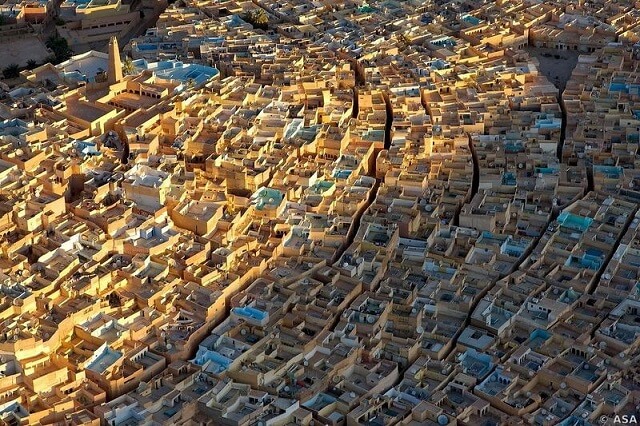
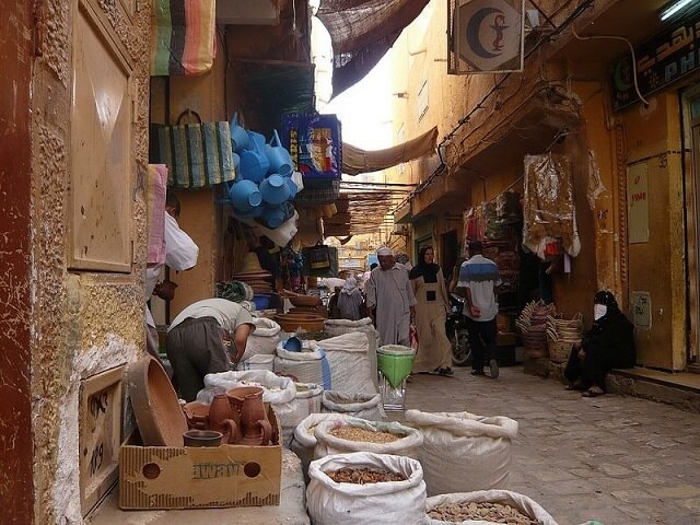
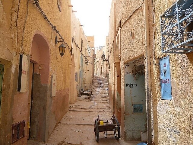
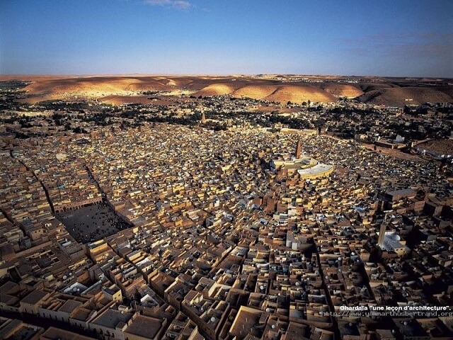
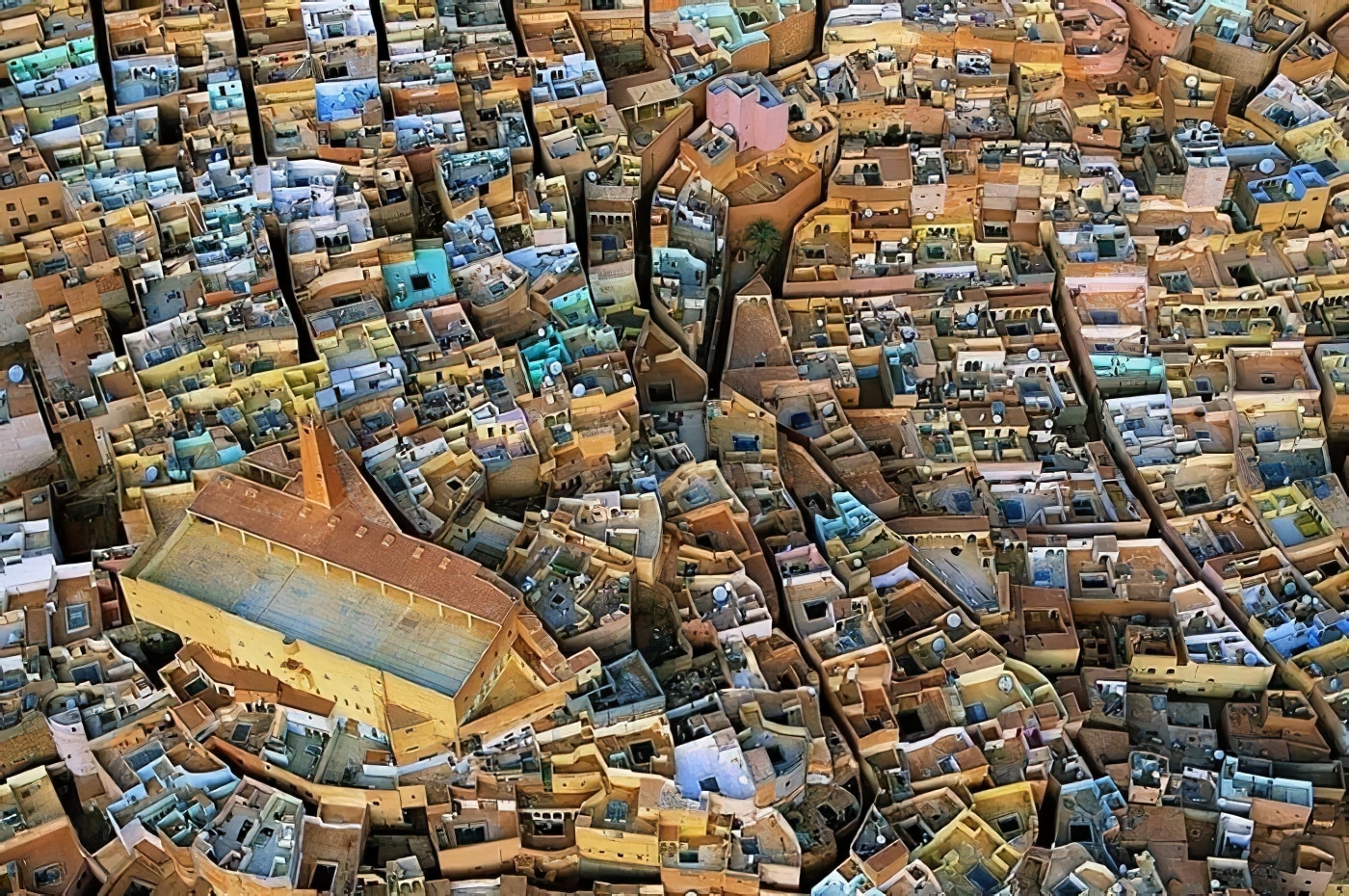
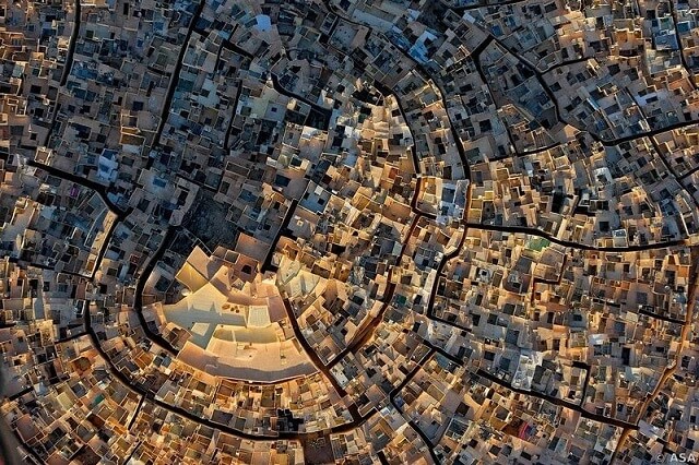
The M’zab Valley in Algeria, home to the fortified villages, stands as an enduring testament to architectural ingenuity and cultural resilience. Located in the heart of the Sahara, about 600 kilometers south of Algiers, this deep and narrow valley hosts five remarkable fortified villages that date back to the 11th century. Spread over a distance of approximately 10 kilometers, these villages — Ghardaia, Beni Isquen, Melika, Bou Noura, and El Atteuf — present a striking example of urban planning that is both simple and functional, seamlessly integrated with the harsh desert environment.
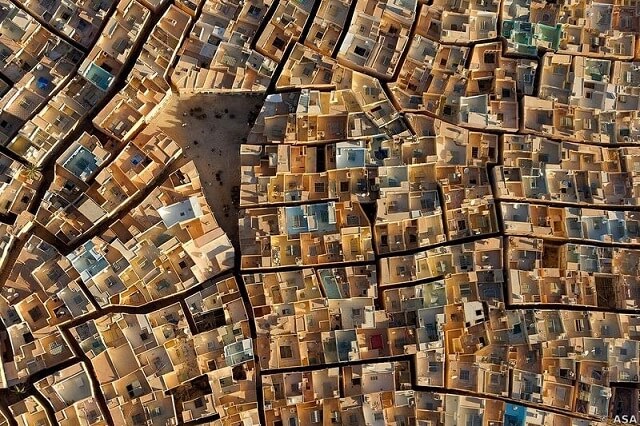
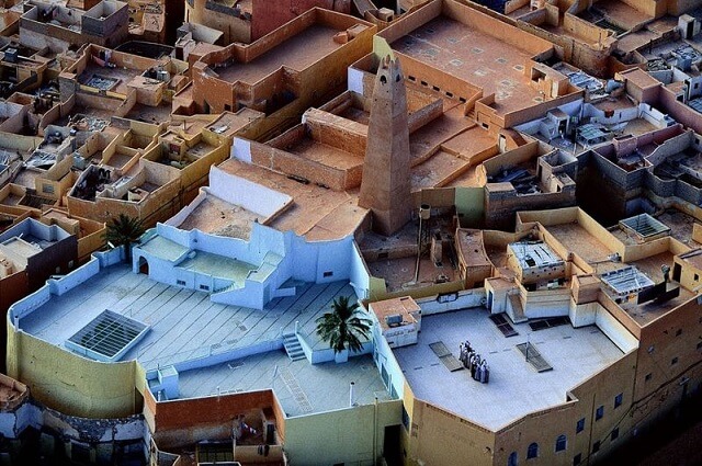
Designed by the Mozabite Berbers, each of these towns is strategically built upon a hill, providing a natural fortification. The architecture is characterized by a tangle of pastel-colored houses, densely packed together. This unique layout follows a concentric circular design, with the houses grouped around a central mosque, which is invariably located at the highest point of the hill. This central placement of the mosque not only signifies its importance in the community but also contributes to the cohesive urban structure that defines these towns.
Remarkably, these villages have maintained their authenticity and original state over the centuries. They appear almost frozen in time, continuing to reflect the enduring nature of a sedentary civilization that has preserved its cultural identity and social cohesion in the face of time and environmental challenges. The M’zab Valley, with its fortified villages, serves as a source of inspiration for urban planners and architects worldwide, demonstrating how traditional design principles can create sustainable and resilient communities in challenging environments.
In the heart of the M’zab Valley’s fortified towns, the mosques were strategically positioned and meticulously designed to serve multiple vital functions. Placed centrally within each town and elevated on the highest points, these mosques were not only religious centers but also acted as veritable fortresses and watchtowers. This dual purpose underscores the mosques’ significance in the Mozabite Berber communities, both as places of worship and as integral components of the towns’ defense systems.
The residential architecture of these towns is equally thoughtful and innovative. The houses, nestled in the narrow and winding streets, were designed to foster a sense of community while simultaneously respecting family privacy. This balance is achieved through an ingenious architectural system that allows for close communal living without encroaching on individual family spaces. Each home, while part of the larger urban fabric, retains a sense of seclusion and personal space.
This harmonious blend of communal and private living, set within the context of a fortified urban layout, demonstrates a sophisticated understanding of social dynamics and environmental adaptation. The M’zab Valley’s towns thus represent a remarkable historical example of community-oriented urban design that remains relevant and inspiring to contemporary urban planners and architects.
The five cities of the M’zab Valley, while architecturally similar, each possess their own distinct identity. Ghardaïa, the main town and capital of the M’zab, serves as the region’s hub. El-Ateuf is notable for being the oldest settlement in the area. Beni Isquen, perhaps the most enigmatic of all the towns in the valley, is considered sacred. Historically, it was closed and fenced at nightfall, a practice that has since ceased. However, Beni Isquen still retains the most traditional settlement in the entire M’zab region.
The cultural practices of the women in these towns are particularly notable, as described by Jonathan Oakes in his travel guide to Algeria. Following tradition, women here wear the haik, a large cloth wrapped around the body and face, typically allowing only one eye to be visible. This custom changes slightly before and after marriage. Unmarried young women are allowed to show their faces, but married women traditionally show only one eye.
These practices also extend to interactions in public spaces. In the past, women faced the wall when strangers passed, a custom no longer widely practiced. However, women still tend to avoid direct gaze and may change their path when encountering strangers. While these women’s appearances are striking, it’s important to respect their privacy and cultural norms. Photography of these women is strictly prohibited and considered disrespectful, often leading to strong disapproval.
These customs highlight the rich cultural heritage of the M’zab Valley, where traditional practices are preserved and respected, offering a glimpse into a way of life that has endured through the centuries.
The fortified towns of the M’zab Valley stand as remarkable examples of the enduring interplay between tradition and religion. Despite the passage of years and even centuries, the communities in these towns have successfully preserved their culture and original state. This steadfast adherence to their unique identity and traditions, amidst the evolving external world, has been a significant factor in their recognition by UNESCO.
In 1982, the collective heritage and historical importance of these towns were officially acknowledged when they were listed as UNESCO World Heritage Sites. This designation not only highlights their architectural and cultural significance but also underscores the importance of preserving such unique human settlements.
The M’zab Valley’s towns are more than just architectural marvels; they are living embodiments of a rich cultural heritage that has been meticulously maintained over generations. This preservation is a testament to the communities’ resilience and commitment to their way of life, offering valuable insights into the human capacity to sustain and cherish cultural identities in a rapidly changing world.